Many Californians are vulnerable to flooding; here's the serious weather situation residents are facing statewide
- The ONME Newswire

- Feb 22, 2024
- 4 min read
By ONME Newswire and Jeffrey Mount, Gokce Sencan, and Letitia Grenier

During the first couple of weeks of February, California suffered several atmospheric river events, back to back, causing unexpected, Biblical catastrophic flooding. The alarming amount of damage caused during this rainstorms shows how much Californians are not prepared, as well as how some of the old infrastructures in place need to be changed to adapt to the obvious climate changes happening in the state.
Below are the alarming facts published in the Public Policy Institute of California. First, here are some basic definitions of "flooding" terms and general risks:
More than seven million Californians—one in five residents—live in areas at risk of flooding. All 58 counties have a history of severe flood damage, making flood risk the most widespread natural hazard in the state—more pervasive than earthquakes or wildfires.
Flooding comes in many forms, including river floods, coastal floods, and urban floods where intense rainfall overwhelms storm drainage systems.
Aging dams—susceptible to failure during earthquakes or high flows—also pose a risk to some downstream communities. More than 250 dams pose a major risk, though only 16 need immediate attention.
Low-income communities of color throughout the state are disproportionately at risk. Such communities have limited financial capacity to fund flood control upgrades and post-flood recovery efforts.
Economic risks from flooding are high and rising.
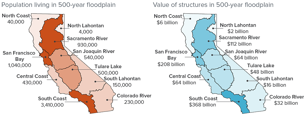
Across California, more than $900 billion dollars in homes and other buildings are at some risk of flooding. A major statewide flood—like those seen in the winter of 1861–62—could displace more than 1.5 million residents and cause over $1 trillion in property damage and business losses.
Climate models show that flood risk is growing as atmospheric rivers—the storms that cause most large floods—become more intense. Risk is also increasing due to sea level rise and slope-destabilizing wildfires.
Most of the state’s flood control infrastructure was designed and built more than 50 years ago, before increasing climate risk was a consideration.

SOURCES: Authors’ calculations, using California Department of Water Resources and US Army Corps of Engineers (California’s Flood Future 2013) (population and structure exposure) and Engineering News Record Building Cost Index (inflation).
NOTES: The population numbers, calculated using the 2000 Census, assume minimal subsequent growth in floodplains. The value of structures was adjusted for inflation from 2010 to 2022 dollars. This estimate is likely low, since it assumes no new construction in floodplains since 2010. A 500-year flood is a flood that has a .2% probability of occurring in any year.
Adapting to rising flood risk will be expensive.
Flood infrastructure—including dams, levees, floodwalls, bypasses, and retention basins—is expensive to permit, build, and maintain.
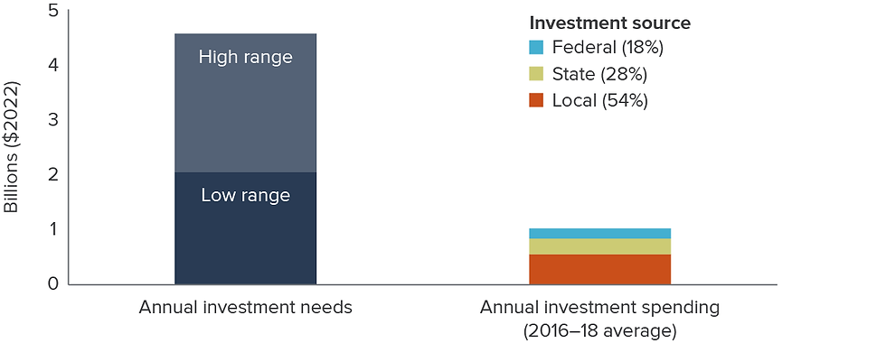
Currently, California spends about $1.8 billion per year for operation and maintenance (O&M) of flood control projects, and $1 billion per year in new investments. Most O&M (>80%) is paid by local fees and taxes.
Several state constitutional provisions make it difficult to raise local funds for flood works. As a result, state and federal sources fund about half of new investments.
Since 2006, more than $4.5 billion in state funding for new flood infrastructure has become available from bonds and recent budget surpluses. California also should see a temporary boost in federal funding from the Bipartisan Infrastructure Law. By comparison, estimated investment needs range from $50 to $115 billion, or $2 to $4.5 billion annually for the next 25 years.

SOURCES: Authors’ calculations using American Society of Civil Engineers (investment needs estimates) and C. Chappelle et al., “Paying for California’s Water System” (PPIC, 2021) (investment spending estimates).
NOTES: Annual investment needs were calculated by applying a 4% discount rate in perpetuity to the total needs estimate. Annual investment spending is the average of 2016–18 capital investment in flood works. All numbers are in 2022 dollars, using the CPI for urban consumers without seasonal adjustment.
Flood insurance and land use planning can help reduce risks.
Flood insurance—managed by the National Flood Insurance Program—is an important tool for reducing social and economic risk from floods. Homes in high-risk areas are required to have insurance if they have a federally backed mortgage.
Approximately 7% of California households at risk of flooding are insured. Less than one quarter of those within special flood hazard zones—where risks are highest—carry insurance.
National Flood Insurance Program premiums are increasing to better reflect risks, but this is making it harder for low-income households to maintain insurance.
Flood-proofing structures and limiting the construction of new homes and businesses in current and future at-risk areas can help reduce flood risk, but this can conflict with local economic development goals. Relocating some businesses and homes is costly, but this may become necessary as risks rise.
Innovations in flood management are likely to help.
Improved near-term forecast technology is helping reservoir operators reduce flood risk and improve water storage.
Floodplain managers widely view minimum federal standards for flood protection as too low. State law requires urban areas in the Central Valley to provide a higher standard of protection.
Changes in federal approaches to funding for technical planning and assistance are expanding resources for low-income communities. And state and federal agencies are evaluating reforms to provide lower premiums to these communities.
Including flood risk reduction as a goal in projects that recharge groundwater and expand wildlife habitat can boost flood resilience and attract additional state and federal funding. Such multi-benefit projects are underway on Central Valley and Southern California rivers.


Comments